


The currents in Long Island Sound are very complex and variable. They are SIGNIFICANTLY affected by wind and lunar cycles, so take care to both plan and change your plans as needed based upon what you observe as you travel.
Long Island Sound is open to the sea at two relatively narrow points:
The Race on the eastern end
 of the Sound is four miles wide and allows water to
enter the Sound directly from the open sea. The East River allows water to
enter the western end of the Sound from New York Harbor. Because the tides
in the Harbor are very different from those in the Sound, this area can produce
extremely tricky currents.
of the Sound is four miles wide and allows water to
enter the Sound directly from the open sea. The East River allows water to
enter the western end of the Sound from New York Harbor. Because the tides
in the Harbor are very different from those in the Sound, this area can produce
extremely tricky currents.
For most of the Sound, tides tend to enter from the eastern end and push to the west. For the very western section of the Sound, the tide pushes weakly in from the East River most of the time. Currents are quickest on the eastern end and tides are highest on the western end. Click here for a map of tidal currents in the Sound. The tide, either high or low, begins at both ends of the Sound and works its way towards the middle of the Sound. Below are tables of high and low tide times and sizes for the south shore of the Sound on the same day. Towns towards the center of the Sound, such as Norwalk and Stamford, CT, have later times for both high and low tides.
High Tide Times
|
Place |
Time |
Feet |
|
New London |
4:22 |
2.52 |
|
Norwalk |
6:08 |
6.71 |
|
Stamford |
6:01 |
6.84 |
|
Port Chester |
5:31 |
6.90 |
|
Rye |
5:19 |
6.81 |
|
New Rochelle |
5:23 |
6.88 |
Low Tide Times
|
Place |
Time |
Feet |
|
New London |
11:08 |
.41 |
|
Norwalk |
12:30 |
.91 |
|
Stamford |
12:33 |
.81 |
|
Port Chester |
11:58 |
1.07 |
|
Rye |
11:48 |
.76 |
|
New Rochelle |
11:57 |
.82 |
As the tide moves in and out, the current that carries it changes significantly. The relationship between high and low tide and maximum current will vary depending on the location, but in general, expect the maximum ebb current to occur an hour or two after high tide, and the maximum flood current to occur an hour or two after low tide. Take a look at the data for Throg's Neck, one of the inlets for water to Long Island Sound. The current here turns around before high and low tide. Maximum current is just after the high and low tide is reached. The data for Stamford, Connecticut has the same basic pattern.
Current and Tide for Throg's Neck
|
Event |
Time |
Feet |
|
High Tide |
5:50 AM |
6.68 Feet |
|
Maximum Ebb Current |
6:50 AM |
.56 knots |
|
Slack Water - Current turns around |
9:27 AM |
00 Knots |
|
Low Tide |
12:30 PM |
.98 Feet |
|
Maximum Flood Current |
1:09 PM |
.84 Knots |
|
Slack Water - Current turns around |
3:58 PM |
00 Knots |
|
High Tide |
6:20 PM |
5.91 Feet |
Current and Tide for Stamford Connecticut
|
Event |
Time |
Feet |
|
High Tide |
5:59 AM |
6.80Feet |
|
Maximum Ebb Current |
8:56 AM |
0.70 knots |
|
Slack Water - Current turns around |
11:43 AM |
0.00 Knots |
|
Low Tide |
12:37 PM |
0.80 Feet |
|
Maximum Flood Current |
2:35 PM |
0.20 Knots |
|
Slack Water - Current turns around |
4:50 PM |
00 Knots |
|
High Tide |
6:27 PM |
5.90 Feet |
Neither current is strong enough to have much effect on a kayaker. All are below one knot. On the same day the currents at The Race are significantly stronger, reaching speeds over 2 knots.
It is important to remember that wind plays just as important a role for a kayaker as tidal currents. As you plan your trip, factor in both wind and tides to get the most out of your day on the water. Beware of tides at both The Race and the other inlet to Long Island Sound, Hell's Gate. Both have significant currents against which you may not be able to paddle. If you do find yourself fighting a significant current, you have some options:
|
Land your boat and wait for the current to subside. | |
|
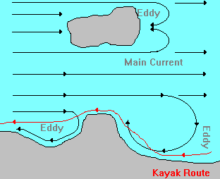
Try to get some shelter from the current by paddling in the lee, or shadow, of a point on the shore or island that may offer you some shelter from the current. |
Eddies do form in tidal currents just the way they do on rivers. Look for them behind islands and points of land that jut out into the open water as shown below:
Use of the information in this guide is at your own risk. Please read our disclaimer.
Copyright 2005 - by Jacob Tanenbaum. All rights are reserved.